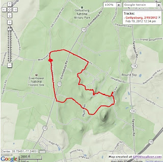
Gettysburg Battlefield Hike: Longstreet's July 2nd Attack
The blog post details a 7-mile hike through many of the most-pivotal spots in the three-day battle.
The morning was clear and cool - perfect hiking weather. But I was then confronted with a change of plans - I didn't have the full day free, I had to be back in the late afternoon, and Gettysburg is a 2+ hour drive each way. Maybe I should have changed my plan and done another hike closer to home - but I had Gettysburg in my mind at that point, and I wanted to walk the field, so I decided I'd still make the trip, but would cut the hike short.
I arrived at the battlefield and got to the starting point at the Longstreet observation tower on Confederate drive. I remember as a boy that there was an identical observation tower in Valley Forge N.P. - but it's long since gone (way too much potential liability, I'm sure.)
I walked on a dirt road through an open field toward Big Round Top, with the monuments on Little Round Top clearly visible. My first alteration of the hike was skipping the trail to the top of Big Round Top. I followed the path to the top of Little Round Top, passing the monument for the 20th Maine on the south slope.
Then I descended west into Devil's Den, then up to the Peach Orchard. At this point, I had to abandon the hike as detailed and try to get back to my car at the Longstreet tower. I could see the tower, probably a half-mile or more away directly to the west, but I thought I'd better stick with the dirt road, which was running north/south.
I finally found a road that went west, made my way back to Confederate Lane, then a short distance south back to my car.
This was a fun hike, and I'm glad I decided to do it, despite having to truncate my original plan. But that original plan is still on my list of hikes to do, and I'll be more than happy to return to Gettysburg for more battlefield walking.
Distance: 4.47 miles
Elapsed Time: 1:23


Dave,
ReplyDeleteI am glad you enjoyed the hike from my blog, civilwarhikes.blogspot.com