Wednesday, February 29, 2012

Lyme Disease, Again

Lyme prevalence by state
It isn't confirmed yet, as the results of the blood test I took today aren't back, but it seems that I have Lyme disease again. I woke up Monday morning basically immobilized with fever and chills, and have spent the last two days flat on my back in bed.

I went to the doctor this morning and told her I've been hiking recently, and they ordered bloodwork - both to confirm Lyme, and to make sure there aren't any other infections going on. They also started me on a 30-day program of Doxycycline.

I say "again" in the title of this post because I think I had Lyme in June '08. I know the date because I wasn't able to attend Ryan's high school graduation. I was bedridden with fever and chills then, and though I never tested positive for Lyme, as soon as they started me on antibiotics, I felt better almost instantaneously. So I'm hoping to have the same result this time.

Thinking about where I could have picked this up, my Gettysburg hike a week ago Sunday seems the most likely culprit. But it could even have been my Honeymoon Isle hike three weeks ago.

Lyme is one nasty bug, and also quite serious - if untreated, it can have very serious long-term neurological effects. And the deer ticks that spread it are so small that they're practically invisible. I don't think I've ever seen a deer tick, though obviously I've been bitten. I have also never had the classic bulls-eye rash symptom, but maybe it's in a place that I wouldn't see it, like my back or above my hairline.

I'm a little disappointed in myself, and that having had Lyme, I should be more careful about protecting myself. Mainly, that means insect repellent with DEET, which I need to apply whenever I step off of asphalt. More ways to prevent it are here.

I don't want to stop hiking, and moving to a Lyme-free place isn't a realistic option in the near term (much as I love Arizona and Utah.) I just need to be more careful, and I resolve to be. This isn't fun, and I will do my best not to get this again.

Sunday, February 26, 2012

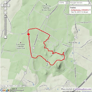
Gettysburg NMP, 2/19/12

Last Sunday, I thought I had a full day to hike, and I came up with an ambitious plan. I've toured the Gettysburg battlefield any number of times, but I've never walked it - and I found a number of good options. This one looked great:
Gettysburg Battlefield Hike: Longstreet's July 2nd Attack

The blog post details a 7-mile hike through many of the most-pivotal spots in the three-day battle.

The morning was clear and cool - perfect hiking weather. But I was then confronted with a change of plans - I didn't have the full day free, I had to be back in the late afternoon, and Gettysburg is a 2+ hour drive each way. Maybe I should have changed my plan and done another hike closer to home - but I had Gettysburg in my mind at that point, and I wanted to walk the field, so I decided I'd still make the trip, but would cut the hike short.

I arrived at the battlefield and got to the starting point at the Longstreet observation tower on Confederate drive. I remember as a boy that there was an identical observation tower in Valley Forge N.P. - but it's long since gone (way too much potential liability, I'm sure.)

I walked on a dirt road through an open field toward Big Round Top, with the monuments on Little Round Top clearly visible. My first alteration of the hike was skipping the trail to the top of Big Round Top. I followed the path to the top of Little Round Top, passing the monument for the 20th Maine on the south slope.

Then I descended west into Devil's Den, then up to the Peach Orchard. At this point, I had to abandon the hike as detailed and try to get back to my car at the Longstreet tower. I could see the tower, probably a half-mile or more away directly to the west, but I thought I'd better stick with the dirt road, which was running north/south.

I finally found a road that went west, made my way back to Confederate Lane, then a short distance south back to my car.

This was a fun hike, and I'm glad I decided to do it, despite having to truncate my original plan. But that original plan is still on my list of hikes to do, and I'll be more than happy to return to Gettysburg for more battlefield walking.

Distance: 4.47 miles
Elapsed Time: 1:23

Thursday, February 9, 2012

Honeymoon Island State Park, 2/5/12

Last week, Darling Wife and I were able to have a long weekend getaway to Clearwater, FL. She wanted to spend Sunday morning at the Clearwater Marine Aquarium, so I looked around for a local day-hike I could do. I found a good candidate just a few miles away, at Honeymoon Island State Park. Darling Wife said it sounded like I was going on a romantic getaway by myself, but I assured her that it was a state park and a nature preserve, with hiking trails.

The park is located in Dunedin, which is the next town north of Clearwater, and I easily found the trailhead. I had carelessly gotten a bit of sunburn the day before by underestimating the strength of the Florida sun - so I made sure I was fully sunscreened before getting outside. The day was hot and sunny with temps between 75 and 80, so I was wearing hiking shorts and a short-sleeve polypro wicking shirt.

At the trailhead parking lot, I saw groups of birders, recognizable by their fancy optics. One group was looking up at big pine tree bordering the parking lot, and I joined them in watching a big osprey perched on a high branch and feeding on a fish.

The next thing I saw in the parking lot was a big sign warning of venomous snakes - that there are 10 species of snakes on the island, and three of them are poisonous (two kinds of rattlesnake, and coral snakes.) This had me a little nervous - at home, I carry a hiking pole for exactly that reason - as something I could use to protect myself from a snake if I happen to find one at my feet. I had shorts on and no poles, so I planned to be extra careful about looking where I stepped.

I started on the Osprey Trail, and my snake fears were eased right away. The trail was sandy, clear, and reasonably wide - wide enough that I was pretty sure a snake would be visible - especially the brightly-banded coral snake.

I've never been on a trail as appropriately-named as this one. There were ospreys everywhere - their calls were always in my ears, their nests were at frequent intervals high in the bare trees, and they were often in sight, either soaring in the sky or perches in the trees.

The trail went north through scrubby forest, until it the forward path was blocked. There was a sign saying that a bald eagle nest was ahead, and they're keeping people away from it. So I made a left turn onto the Pelican Trail. This trail went all the way to the north tip of the island.

I then turned around and followed the Pelican Trail. This trail was soft white sand, and followed the water's edge for a while. After a while, I cut back inland and followed the trail back to the parking lot.

The hike wasn't strenuous, but it was a fun hike with scenery that was not only beautiful but very different from what I'm used to. And I'm familiar with ospreys from the Chesapeake, but I have never seen such a concentration of them.

Total miles: 2.67
Elapsed time: 1:22